at Smith Rock
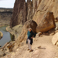
Just 15 minutes from our house lies Smith Rock, a formation of jagged yellow and purple walls and towering spires. Smith Rock was formed by the eruption of a "supervolcano" called the Crooked River Caldera roughly 29 million years ago. Today Smith Rock is a popular rock climbing destination, where climbers from all over the world come to test their skills. It's a great place for hikers as well. Your reward for making it to the top of Smith Rock is a spectacular views of the Cascades.
on the Metolius River

Thirty miles to the east you will find yourself in great ponderosa pine forests. The beautiful Metolius River originates as a natural spring at the base of Black Butte. Numerous springs, which seep through porous volcanic rock, feed the river along its route as it flows into Lake Billy Chinook. In this picture what looks like a waterfall is actually a spring feeding the river.
at Lake Billy Chinook
Lake Billy Chinook is formed by the confluence of three rivers, the Metolious River, the Crooked River and the Deschutes River. Crooked River Ranch, where Ted and I live, is bordered on the east by the Crooked River and on the west by the Deschutes River as they flow toward Lake Billy Chinook. The lake is home to one of our favorite hikes along the Tam-a-lau Trail. The hike takes you up a rocky plateau called the Peninsula, formed by rock and sediment deposited by the Deschutes River over a thousand years ago. From the top you are afforded views of the vast reservoir below as well as many of the Cascades.
Go Ted Go!
ReplyDelete